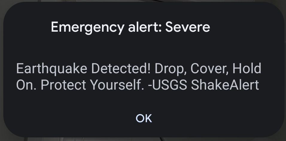
helvede.net is one of the many independent Mastodon servers you can use to participate in the fediverse.
Velkommen til Helvede, fediversets hotteste instance! Vi er en queerfeministisk server, der shitposter i den 9. cirkel. Welcome to Hell, We’re a DK-based queerfeminist server. Read our server rules!

Server stats:

160
active users

#WEA

1 post1 participant0 posts today

#EAS #WEA for Carter, #MO: National Weather Service: A FLASH #FLOOD EMERGENCY is in effect for this area until 1:30 AM CDT. This is an extremely dangerous and life-threatening situation. Do not attempt to travel unless you are fleeing an area subject to flooding or under an evacuation order. Source: NWS Paducah KY ** DO NOT RELY ON THIS FEED FOR LIFE SAFETY, SEEK OUT OFFICIAL SOURCES ***

#EAS #WEA for Riverside: An Evacuation Order has been issued for the following area: South of 7th St, West of Santa Fe, East of Palm, North of Fruitvale Source: Public Alert System ** DO NOT RELY ON THIS FEED FOR LIFE SAFETY, SEEK OUT OFFICIAL SOURCES ***

#EAS #WEA for MI Oakland County: ACTIVE SHOOTER reported near Troy Corewell Health Beaumont Hospital (M59 and Dequindre). AVOID the area and SHELTER in place. Law enforcement on scene. Tune to local media for more information. Source: 200188,MI Oakland County, ** DO NOT RELY ON THIS FEED FOR LIFE SAFETY, SEEK OUT OFFICIAL SOURCES ***

Replied to EAS Watcher

@easwatch #OKwx #EAS #WEA for Pawnee: Pawnee County EM: A dangerous wildfire is located near Oak Grove spreading rapidly NNE. This area is in IMMEDIATE DANGER from wildfires which can cause injury/death, burn down homes/other structures. LEAVE NOW toward the Mannford. Do not delay to pack belongings. Reunification Center is setting up at Mannford Methodist Church. Roads in the area may be impact Source: Oklahoma Emergency Management ** DO NOT RELY ON THIS FEED FOR LIFE SAFETY, SEEK OUT OFFICIAL

#EAS #WEA for Pawnee: Pawnee County EM: A dangerous wildfire is located near Oak Grove spreading rapidly NNE. This area is in IMMEDIATE DANGER from wildfires which can cause injury/death, burn down homes/other structures. LEAVE NOW toward the Mannford. Do not delay to pack belongings. Reunification Center is setting up at Mannford Methodist Church. Roads in the area may be impact Source: Oklahoma Emergency Management ** DO NOT RELY ON THIS FEED FOR LIFE SAFETY, SEEK OUT OFFICIAL SOURCES ***

#EAS #WEA for Bernalillo, #NM; #Sandoval, #NM; #Valencia, #NM: National Weather Service: DUST STORM WARNING for this area until 4:15 PM MDT. Be ready for sudden drop to zero visibility. Pull Aside, Stay Alive! When visibility drops, pull far off the road and put your vehicle in park. Turn the lights off and keep your foot off the brake. Infants, the elderly and those with respiratory issues urged to take precautions. Source: NWS Albuquerque NM ** DO NOT RELY ON THIS FEED FOR LIFE SAFETY, SEEK O

#EAS #WEA for Wayne, #MO: National Weather Service: #TORNADO WARNING in this area until 10:45 PM CDT. Take shelter now in a basement or an interior room on the lowest floor of a sturdy building. If you are outdoors, in a mobile home, or in a vehicle, move to the closest substantial shelter and protect yourself from flying debris. Check media. Source: NWS Paducah KY ** DO NOT RELY ON THIS FEED FOR LIFE SAFETY, SEEK OUT OFFICIAL SOURCES ***

#EAS #WEA for Wayne, #MO: National Weather Service: #TORNADO WARNING in this area until 10:45 PM CDT. Take shelter now in a basement or an interior room on the lowest floor of a sturdy building. If you are outdoors, in a mobile home, or in a vehicle, move to the closest substantial shelter and protect yourself from flying debris. Check media. Source: NWS Paducah KY #Wayne, #MOwx** DO NOT RELY ON THIS FEED FOR LIFE SAFETY, SEEK OUT OFFICIAL SOURCES ***

#EAS #WEA for Tazewell, #IL: National Weather Service: #TORNADO WARNING in this area until 10:45 PM CDT. Take shelter now in a basement or an interior room on the lowest floor of a sturdy building. If you are outdoors, in a mobile home, or in a vehicle, move to the closest substantial shelter and protect yourself from flying debris. Check media. Source: NWS Lincoln IL ** DO NOT RELY ON THIS FEED FOR LIFE SAFETY, SEEK OUT OFFICIAL SOURCES ***

#EAS #WEA for Carter, #MO; #Ripley, #MO; #Wayne, #MO: National Weather Service: #TORNADO WARNING in this area until 11:00 PM CDT. Take shelter now in a basement or an interior room on the lowest floor of a sturdy building. If you are outdoors, in a mobile home, or in a vehicle, move to the closest substantial shelter and protect yourself from flying debris. Check media. Source: NWS Paducah KY #Carter, #MO; #Ripley, #MO; #Wayne, #MOwx** DO NOT RELY ON THIS FEED FOR LIFE SAFETY, SEEK OUT OFFICIAL

#EAS #WEA for Clinton, #IL; #Madison, #IL; #Monroe, #IL; #St. Clair, #IL; #Washington, #IL: National Weather Service: #TORNADO WARNING in this area until 11:00 PM CDT. Take shelter now in a basement or an interior room on the lowest floor of a sturdy building. If you are outdoors, in a mobile home, or in a vehicle, move to the closest substantial shelter and protect yourself from flying debris. Check media. Source: NWS St Louis MO #Clinton, #IL; #Madison, #IL; #Monroe, #IL; #St. Clair, #IL; #Wa

#EAS #WEA for Alameda, #CA: AN EBONY ALERT HAS BEEN ACTIVATED BY THE CALIFORNIA HIGHWAY PATROL ON BEHALF OF THE OAKLAND POLICE DEPARTMENT. LEILANI BISHOP IS MISSING AND ENDANGERED. LEILANI BISHOP WAS LAST SEEN ON MARCH 10, 2025, AT APPROXIMATELY 0500 HOURS, IN OAKLAND CLICK ON THE LINK FOR ADDITIONAL INFORMATION. bit.ly/E016-2025 Source: 200230,California Highway Patrol,CA California Highway Patrol ** DO NOT RELY ON THIS FEED FOR LIFE SAFETY, SEEK OUT OFFICIAL SOURCES ***

X (formerly Twitter)CHP - Alerts (@CHPAlerts) on XEbony Alert - Alameda County Last seen: 66th Avenue and MacArthur Blvd, Oakland @oaklandpoliceca IF SEEN, CALL 9-1-1.

#EAS #WEA for Los Angeles: Emergency message from LASD: 03/11/25 12:00 pm: Deputies are in the field notifying residents of local mud/debris flow risk from Bridge Fire burn scar. The areas of Mt. Baldy around Glendora Ridge Rd are under EVACUATION WARNING until at least 3/13/25 6:00 pm due to risk to access. PREPARE NOW. More info at alertla.org. Source: Public Alert System ** DO NOT RELY ON THIS FEED FOR LIFE SAFETY, SEEK OUT OFFICIAL SOURCES ***

#EAS #WEA for Los Angeles: Emergency message from LASD: 03/11/25 12:00 pm: Deputies are in the field notifying residents of local mud/debris flow risk from Bridge Fire burn scar. The areas of East Fork Rd and Communities along the San Gabriel River are under EVACUATION WARNING until at least 3/13/25 6pm due to risk of losing access. PREPARE NOW. More info at alertla.org. Source: Public Alert System ** DO NOT RELY ON THIS FEED FOR LIFE SAFETY, SEEK OUT OFFICIAL SOURCES ***

#EAS #WEA for Los Angeles, #CA: A SILVER ALERT HAS BEEN ACTIVATED BY THE CALIFORNIA HIGHWAY PATROL ON BEHALF OF THE ALHAMBRA POLICE DEPARTMENT. SHI LI IS MISSING AND ENDANGERED. SHI LI WAS LAST SEEN ON MARCH 7, 2025, IN ALHAMBRA, LOS ANGELES COUNTY. CLICK ON THE LINK FOR ADDITIONAL INFORMATION. bit.ly/S098-2025 Source: 200230,California Highway Patrol,CA California Highway Patrol ** DO NOT RELY ON THIS FEED FOR LIFE SAFETY, SEEK OUT OFFICIAL SOURCES ***

#EAS #WEA for Colbert, #AL; #Franklin, #AL; #Lawrence, #AL: National Weather Service: #TORNADO WARNING in this area until 11:30 PM CST. Take shelter now in a basement or an interior room on the lowest floor of a sturdy building. If you are outdoors, in a mobile home, or in a vehicle, move to the closest substantial shelter and protect yourself from flying debris. Check media. Source: NWS Huntsville AL #Colbert, #AL; #Franklin, #AL; #Lawrence, #ALwx** DO NOT RELY ON THIS FEED FOR LIFE SAFETY, SE

#EAS #WEA for Los Angeles: LAFD: EVACUATION WARNING for possible debris flows in effect from 7am Thurs-2pm Fri. Prepare for possible evacuations in the Palisades Fire area near Mandeville Canyon due to a storm with heavy rain. High risk houses in the warning area will be visited by LAPD with specific evacuation orders lafd.org/alert Source: 200277,LA City Public Alerts,City of Los Angeles ** DO NOT RELY ON THIS FEED FOR LIFE SAFETY, SEEK OUT OFFICIAL SOURCES ***

#EAS #WEA for Knox, #KY; #McCreary, #KY; #Whitley, #KY: National Weather Service: #TORNADO WARNING in this area until 7:45 PM EST. Take shelter now in a basement or an interior room on the lowest floor of a sturdy building. If you are outdoors, in a mobile home, or in a vehicle, move to the closest substantial shelter and protect yourself from flying debris. Check media. Source: NWS Jackson KY ** DO NOT RELY ON THIS FEED FOR LIFE SAFETY, SEEK OUT OFFICIAL SOURCES ***

#EAS #WEA for Breathitt, #KY; #Clay, #KY; #Jackson, #KY; #Owsley, #KY; #Perry, #KY: National Weather Service: #TORNADO WARNING in this area until 8:45 AM EST. Take shelter now in a basement or an interior room on the lowest floor of a sturdy building. If you are outdoors, in a mobile home, or in a vehicle, move to the closest substantial shelter and protect yourself from flying debris. Check media. Source: NWS Jackson KY ** DO NOT RELY ON THIS FEED FOR LIFE SAFETY, SEEK OUT OFFICIAL SOURCES ***